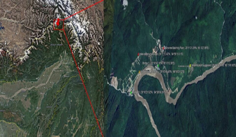

Satellite imagery reviewed by Indian geospatial firm EarthSense Labs points to land clearing, a new access road and possible river diversion works at Mainling in Tibet, where China formally launched its massive Medog hydropower project in July 2025. The findings have renewed concerns about downstream river flows, sediment movement and communities in Arunachal Pradesh and Assam.
The project is on the lower Yarlung Tsangpo, which enters India as the Siang in Arunachal Pradesh before becoming the Brahmaputra in Assam. It has a reported planned capacity of 60,000 megawatts and is expected to comprise five hydropower stations built in succession, at an estimated investment of 1.2 trillion yuan, or about USD 168 billion when announced. China says the project will supply electricity to Tibet and other parts of the country without significantly affecting downstream water availability.
In its Discovery Report, EarthSense Labs said imagery of Mainling showed land clearing in settlement and agricultural areas on the river’s south bank, upstream of the proposed dam site. It identified a newly built access road on the north bank and what it called possible river diversion works-a standard dam-construction step involving temporary rerouting of a river to allow work on the main structure.
Dr Nirdesh Kumar Sharma, EarthSense Labs’ co-founder and CEO, said the company analysed satellite imagery with tender records to identify Pai and Xirang as two other potential dam locations. Its assessment suggests the complex could involve tunnels beneath the Namcha Barwa massif to divert water through a section of the Great Bend of the Yarlung Tsangpo. China has publicly identified Mainling as the groundbreaking site; the Pai and Xirang locations and tunnel alignment are based on EarthSense’s analysis.
EarthSense Labs said reservoir filling and water releases for power generation could alter the Siang’s natural flow, especially in the dry season, while a cascade of stations could trap some sediment carried to Assam’s floodplains. The extent would depend on storage capacity, release schedules and downstream tributaries.
The concerns are significant for a region that has seen devastating floods tied to sudden upstream changes. In 2000, a landslide blocked the Yigong River in Tibet, a Yarlung Tsangpo tributary, creating a natural dam; when it breached, water surged into Arunachal Pradesh and reached the Brahmaputra floodplains. The Centre told Parliament in 2025 that China stopped sharing Brahmaputra hydrological data in June 2023 after a bilateral agreement expired, and India sought resumption.
The findings come amid opposition in Arunachal Pradesh to the proposed 11,200-MW Siang Upper Multipurpose Project, where survey and drilling for a pre-feasibility study have triggered protests. The state government says the reservoir could help regulate upstream flow changes and protect against impacts from China’s project. Sections of the Indigenous Adi community oppose it over displacement, ancestral land and livelihoods. The Siang Indigenous Farmers’ Forum alleges affected landowners were not adequately consulted. Opposition escalated into violence in Pasighat on October 23, damaging property and injuring police. The analysis offers signs of activity at Medog, but the downstream impact and the Siang reservoir’s effectiveness remain uncertain.
Original Source: https://www.indiatodayne.in/arunachal-pradesh/story/satellite-imagery-points-to-river-diversion-works-at-chinas-medog-hydropower-site-upstream-of-arunachal-1478523-2026-11-22?utm_source=rssfeed
Category:
Tags:
Publish Date: 2026-11-22 21:10:00